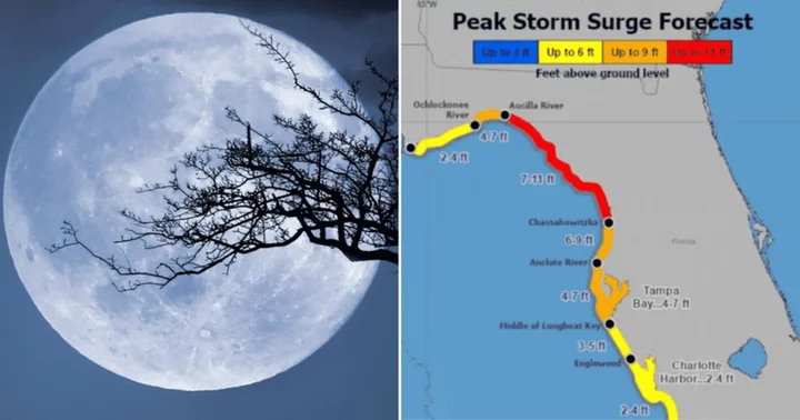
TAMPA, FLORIDA: A rare blue supermoon, that is supposed to occur on the night of Wednesday, August 30, may cause higher tides as Hurricane Idalia approaches Florida's west coast, worsening potential flooding.
Hurricane Idalia is expected to hit Florida on the same day, and the stronger gravitational pull caused by supermoons can lead to elevated tides.
Anticipated effects include exacerbating tidal flooding in Florida as well as in states like Georgia and South Carolina. Haines' office has cautioned residents, indicating that portions of Charleston might experience flooding by Wednesday night.
"I would say the timing is pretty bad for this one," said Brian Haines, the meteorologist in charge at the National Weather Service in South Carolina, as per AP News.
What is a blue supermoon?
A blue supermoon refers to a unique celestial event when the second full moon in a calendar month (known as a "blue moon") is at its closest proximity to Earth in its elliptical orbit (a phenomenon referred to as a "supermoon").
This alignment results in a larger and brighter appearance of the moon in the night sky. Blue supermoons are relatively rare, as the last one was in December 2009, and the next one will not be seen until January 2037.
The blue supermoon of Wednesday, August 30, will appear full till Friday, September 1.
When the moon reaches its full phase, it ends up exerting gravitational forces in the same direction as the sun, causing an elevation in tides beyond their normal ranges.
Kerry Emanuel, a professor emeritus of atmospheric science at the Massachusetts Institute of Technology, explains that when the moon is closer to Earth, its gravitational influence becomes even more potent, leading to higher tides, according to AP News.
In the context of hurricanes, storm surges often pose the most substantial threat as during such occurrences the ocean water is pushed onto land, leading to unprecedented damages.
Hurricane Idalia to reach the Florida coast on August 30 morning
As of Monday afternoon, August 28, the storm was situated off the western tip of Cuba, registering maximum sustained winds of 65 miles per hour, as stated in a National Hurricane Center (NHC) advisory.
The predictions suggest that Idalia will reach the Florida coast on Wednesday morning, accompanied by hurricane-force winds. Meteorologists anticipate a storm surge of up to 10 feet in Tampa Bay, which could bring life-threatening consequences. It was declared a Category 4 storm at 5 am EDT on August 30.
The National Hurricane Center's recent briefings project that the storm surge could be as high as 15 feet (4.6 meters) along parts of Florida's west coast. Additionally, the Tampa Bay area might experience up to 7 feet (2.1 meters) of storm surge.


