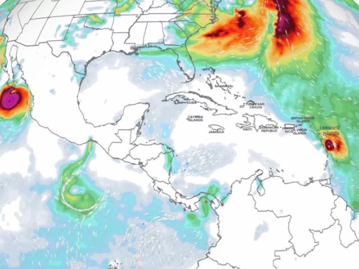
Hurricane Norma is expected to strike Mexico's popular Los Cabos resort area from the Pacific Ocean on Saturday with destructive winds and a dangerous storm surge, even while a different hurricane swipes island nations in the Atlantic.
Norma, a Category 3 storm in the Pacific Ocean as of early Saturday, is expected to move over or near parts of Mexico's Baja California Sur -- including Cabo San Lucas -- late Saturday afternoon or early evening, the National Hurricane Center said.
Norma is expected to be weaker than Category 3 by the time it hits land, but it still will be a hurricane that could bring life-threatening conditions to a tourist-friendly region that's home to a few hundred thousand people, the hurricane center said.
In the Atlantic Ocean, meanwhile, Hurricane Tammy -- a Category 1 storm as of early Saturday -- has triggered hurricane warnings for portions of the Leeward Islands, a chain of several island nations and territories between the Caribbean Sea and the open Atlantic.
Neither storm is a threat to the US.
As for Norma: With maximum sustained winds of 115 mph, it was centered about 85 miles south of Cabo San Lucas as of early Saturday, and rain and tropical storm conditions already were hitting land, the hurricane center said.
A hurricane warning was in effect for south parts of Baja California Sur, including Cabo San Lucas.
A dangerous storm surge "is likely to produce coastal flooding in areas of onshore winds within the hurricane warning area" Saturday, the hurricane center said.
"Near the coast, the surge will be accompanied by large and destructive waves," the hurricane center said.
Norma will bring heavy rainfall and flooding to the area through Sunday. Rainfall totals of 5 to 10 inches with isolated totals approaching 15 inches are possible through Sunday across the far southern portion of California Baja Sur, and through Monday in parts of Mexico's Sinaloa state.
"These rains will likely produce flash and urban flooding, along with possible mudslides in areas of higher terrain," the National Hurricane Center warned.
After raking Baja California Sur, Norma will then make a turn to the east, cross the Gulf of California, and make landfall somewhere along the western coast of mainland Mexico -- likely as a tropical storm -- by Monday morning.
Hurricane Tammy heads for the Leeward Islands
In the Atlantic, Tammy, with maximum sustained winds of 80 mph, was centered about 60 miles east-northeast of Dominica early Saturday, the National Hurricane Center said at 5 a.m. ET.
Tammy is expected to move near or over portions of the Leeward Islands -- including Guadeloupe and Antigua and Barbuda -- through Saturday night, and then move north of the northern Leeward Islands on Sunday.
Hurricane-force winds extended outward up to 25 miles from the storm's center and tropical storm-force winds extended outward up to 125 miles early Saturday.
Hurricanes in this part of the Atlantic are rare for late October. Tammy is only the third hurricane to form this far southeast in the Atlantic since 1900, according to hurricane expert Michael Lowry.
It's also the latest-forming hurricane in this part of the Atlantic since 1966, according to Phil Klotzbach, a research scientist in the Department of Atmospheric Science at Colorado State University.
Hurricane experts previously warned hurricanes could form in unusual areas later in the season this year because of the exceptionally warm Atlantic Ocean.
A storm surge of 1 to 3 feet is possible for parts of the Leeward Islands.
Heavy rainfall will be one of the storm's most serious threats and could result in flash flooding and mudslides. Rainfall totals for the Leeward Islands are expected to be 4 to 8 inches, but could reach a foot in places where the heaviest rain sets up. Rain should be lighter in Puerto Rico and the British and US Virgin Islands, where 1 to 2 inches of rain is most likely.
Conditions will begin to improve from south to north across the island chain by late Sunday as the storm moves north out of the region.
With Tammy in the Atlantic, only two names are left -- Vince and Whitney -- on the standard Atlantic storm name list before the hurricane center turns to an alternate list of names.