NEW YORK CITY, NEW YORK: Terrifying footage of the eye of Hurricane Lee as it hurtles towards the eastern seaboard has sparked concerns of widespread destruction in its path.
This storm has rapidly escalated from a Category 1 to a Category 5 hurricane overnight, setting the stage for potentially catastrophic consequences.
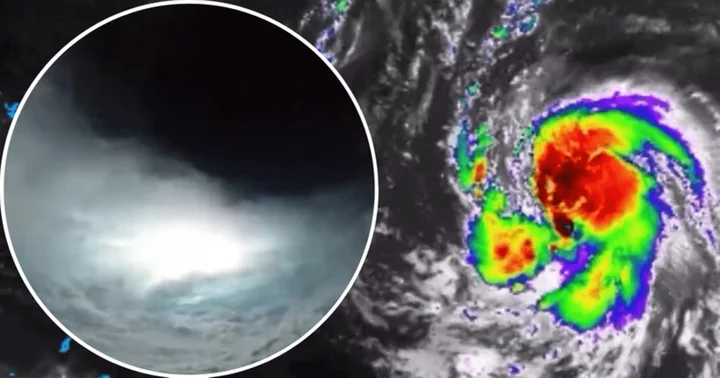
The Air Force's 'Hurricane Hunters', a specialized weather reconnaissance squadron, captured lightning strikes within the heart of the storm. The hair-raising video was shared on social media.
For several days, Hurricane Lee has meandered over the Atlantic Ocean, gradually gaining momentum.
Yet, forecasters have grappled with the challenge of predicting its precise trajectory, and it is not anticipated to make landfall until late next week.
As the East Coast braces for the impending impact, New York City and Boston experienced severe storms on Friday, September 8, due to the hurricane's offshore currents.
Thunder and lightning rattled the Big Apple, while farther north in Massachusetts, strong gusts of winds downed trees and power lines.
Hurricane Lee goes from Category 1 to Category 5
Hurricane Lee was initially registered as a Category 1 hurricane on Wednesday, September 6, originating near the Leeward Islands in the Caribbean.
Meteorologists promptly sounded the alarm regarding its devastating potential.
Satellite projections captured its alarming surge in speed and intensity, reaching over 160 mph by Thursday, September 7, as compared to earlier speeds of around 80 mph.
One key factor contributing to this rapid escalation was the unseasonably warm waters of the Atlantic Ocean, where temperatures along its path have soared to nearly 86 degrees —conditions similar to the Gulf of Mexico.
As of Friday, Hurricane Lee remained a considerable distance off the coastline, approximately 440 miles east of the Leeward Islands, maintaining a northwestward movement at a rate of 13 mph.
Meteorologist and hurricane expert Michael Lowry noted on social media that Hurricane Lee's southeastward position was the farthest ever observed for a Category 5 hurricane in the Atlantic, spanning 172 years of records.
The East Coast may soon witness perilous surf conditions as early as Sunday, September 10, according to the National Hurricane Center.
The center cautioned that although the hurricane's intensity might fluctuate over the next few days, it was expected to remain a major hurricane through the early part of the following week.
Unpredictable path of Hurricane Lee and its impact on the East Coast
Meteorologists' predictions have varied between if Hurricane Lee will directly impact the East Coast or alter its course. Initial forecasts suggested that it might intensify into a major hurricane by the weekend.
However, subsequent discussions deemed it "way too soon to know what level of impacts, if any, Lee might have along the U.S. East Coast, Atlantic Canada, or Bermuda late next week."
This was mainly because the hurricane was expected to decelerate significantly over the southwestern Atlantic, as per the Daily Mail.
The impending weather conditions resulted in the cancellation of over 200 flights from JFK, Newark and LaGuardia airports.
As thunderstorms approached, people took to social media, sharing images of ominous clouds looming over New York.
Reports have indicated that in New Jersey, trees and power lines were toppled by strong winds, prompting severe thunderstorm watches for the entire tri-state area until 11 pm on Friday.
Additionally, flash flood warnings have been issued in parts of the Hudson Valley, following a period of hot and dry conditions.
Large sections of Massachusetts, including Middlesex, Essex, Franklin, Hampden and Hampshire counties, also remain under thunderstorm watch.