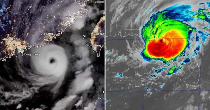
TALLAHASSEE, FLORIDA: You may hear meteorologists discuss abrupt swings in a storm's intensity caused by an 'eyewall replacement cycle'. These cycles are a common phenomenon with strong hurricanes and typhoons which are said to temporarily weaken the impact.
The eyewall replacement cycle phenomenon involves a new eye starting to develop around the old one. The old eye is replaced with the new one, whose diameter gradually shrinks.
Hurricane Idalia was a Category 4 nightmare lurking off Florida's west coast in the last hours before it made landfall, and the storm was expected to keep getting stronger to the coast.
Then the unexpected flip occurred — eyewall replacement cycle — saving the state's capital city of Tallahassee from much worse harm, as reported by Daily Mail.
The eyewall replacement cycle occurs when intensity of hurricane decreases
According to The Weather Prediction, a hurricane's intensity decreases during an eyewall replacement cycle. For instance, a CAT 5 hurricane might become a CAT 4. The gradual degradation of the inner eyewall causes the intensity to decrease.
The storm's intensity will frequently increase as the outer eyewall organizes and contracts. A storm will likely not maintain its CAT 5 status for an extended amount of time due to eyewall replacement cycles.
While an eyewall replacement cycle tends to lower a hurricane's category, it also disperses hurricane-force winds across a wider area. This might render a larger area susceptible to a hurricane's severe destruction.
Kelly Godsey, one of the meteorologists monitoring the storm at the National Weather Service in Tallahassee, explained, "Eyewall replacement cycles are common in major hurricanes, and so when you see that, it does lead to some temporary weakening."
The chance to observe plenty of eyewall replacement cycles has arisen as a result of the dramatic rise in the frequency of extreme hurricanes during the past few years.
An eyewall replacement cycle is extremely difficult for forecast models to predict. Replacement cycles will typically occur with powerful hurricanes, but the timing is unknown.
How long does an eyewall replacement cycle last?
According to NOAA, an eyewall replacement cyclone can last anywhere between 12 and 18 hours and 2 to 3 days to complete, and these cycles can occur again during a tropical cyclone's course.
As per FOX Weather, Typhoon Mawar, which made landfall in late May, performed an eyewall replacement cycle just hours before hitting the coast of Guam, which reduced some of the storm's power.
What are the conditions in the eyewall?
The eyewall of a tropical storm is its most deadly and destructive component. The winds are the highest, the rainfall is the heaviest, and dense convective clouds reach a height of 15,000 meters (49,000 feet) in this region.
Rapid variations in atmospheric pressure close to the eye produce a significant pressure gradient force that propels the strong winds. At a height of around 300 meters (1,000 feet), above the surface, winds achieve their highest speed.
Eyewall replacement cycle saves lives amid Hurricane Idalia
As per the National Hurricane Center, Hurricane Idalia was classified as a Category 4 hurricane around 6 am on Wednesday, August 30, but it was downgraded to a Category 3 when wind speeds slowed to around 120 mph.
Meteorologists refer to the possibly life-saving natural process as the "eyewall replacement cycle," a characteristic of hurricanes before they make landfall.
Hurricane Idalia has a larger eye and an overall extended wind field as a result of the successful completion of an eyewall replacement cycle, increasing the potential for damage over a wider area.
Idalia chose to track over land instead, where friction immediately slowed the wind near the surface.
After the eyewall replacement process had started, the hurricane abruptly turned away from Tallahassee, which is home to around 200,000 people, Florida State University, and thousands more people in the surrounding metro region.
At 7.45 am, the Hurricane Center reported that the storm bypassed Florida's capital city and instead swayed to the north-northeast before making landfall close to Keaton Beach.
Godsey, who told the New York Post that he and his coworkers slept inside the meteorological office on the night of the storm to help monitor the situation, claimed, "Had that turn not occurred, there would have been much more devastating impacts here in Tallahassee."
Idalia was still a powerful hurricane despite the impacts of the eyewall replacement cycle, and it threatened storm surges of up to 15 feet along sections of Florida's coast.
According to Yale Climate Connections meteorologist and journalist Bob Henson, Idalia's inland path over the Southeast United States was rather simple for a storm traveling close to the coast.

